« Back to Bedrock Incision Home
Modeling the effects of weathering on bedrock channel geometry and slope
In bedrock channels, the cross-channel distribution of incision and the overall rate of bedrock channel erosion must depend on three factors:
| 1. | the frequency distribution of floods combined with channel gradient and geometry, which translate into a cross-channel distribution of the river's ability to erode; |
| 2. | the distribution of sediment, which can both protect the bed and provide tools to abrade it [Sklar and Dietrich, 2004; Turowski et al., 2007]; |
| 3. | the cross-channel distribution of bedrock erodibility associated with lithologic variability or produced by chemical and physical weathering [Montgomery, 2004; Stock et al., 2005]. |
We use a model of cross-sectional evolution to explore the role of weathering in the evolution of rock-floored channel geometry and slope. The model follows the strategy of Wobus et al. (2006; 2008) to calculate flow hydraulics and to simulate cross-section erosion. Using this model, we address the following question: Are channel geometry and slope significantly different in channels where weathering increases erodibility compared to channels where weathering is negligible?
Width/depth ratio and erosion rate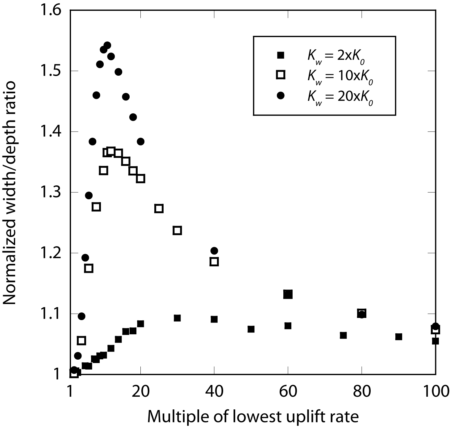
|
Normalized channel width/depth ratio at mean discharge in weathering simulations with where weathering can increase erodibility up to two, ten and 20 times the fresh rock value. Value on x-axis is uplift rate expressed as multiple of the lowest uplift rate used in simulations (U = 0.1 mm/yr). We normalize width/depth ratio for these weathering simulations by dividing by the width/depth (~3.08) obtained when weathering is not allowed (i.e., erodibility remains at fresh rock value. |
Channel geometry and erodibility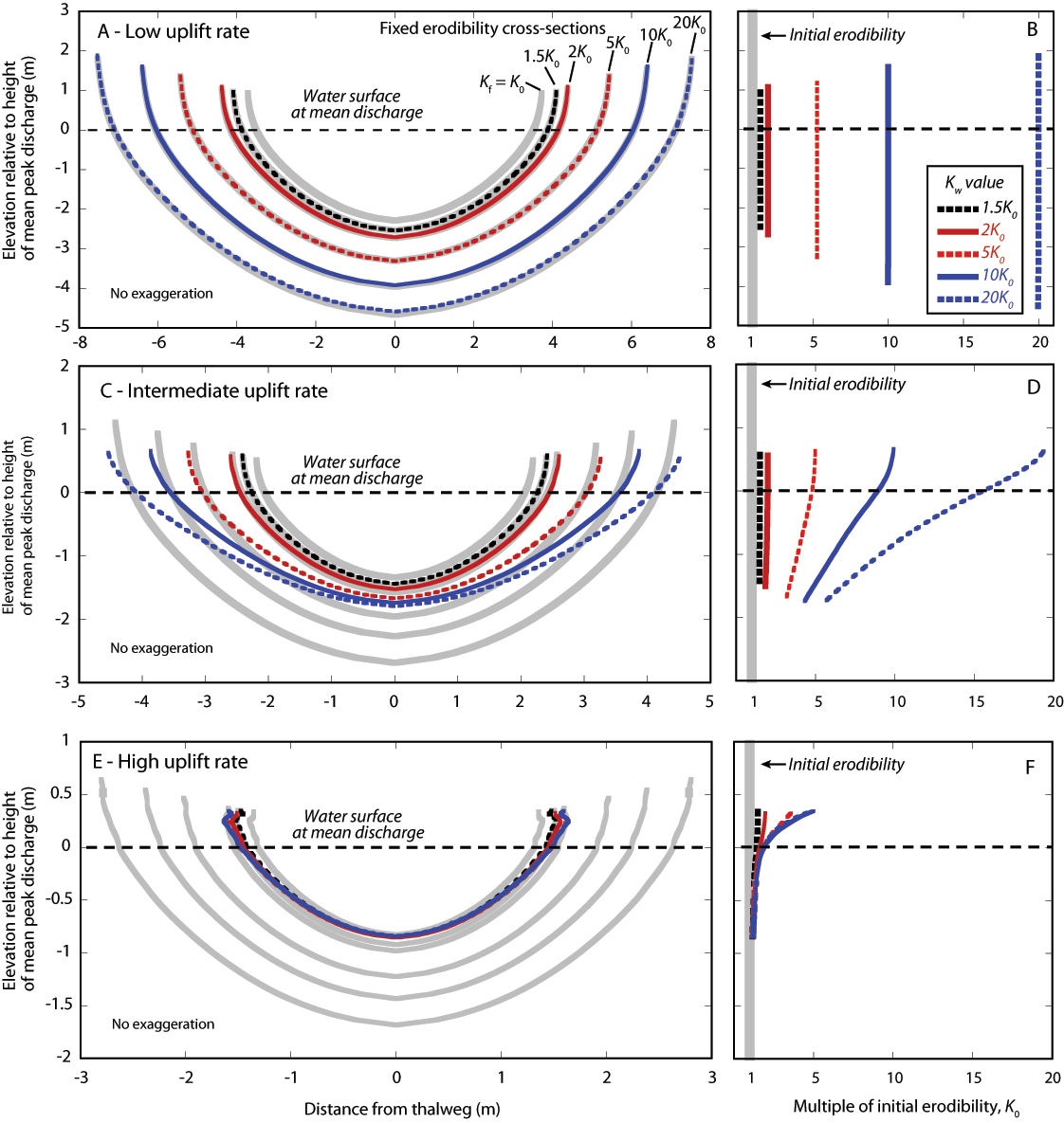
|
Equilibrium channel cross-sections (A, C, and E) and rock erodibility patterns (B, D and F) produced at low, intermediate, and high uplift rates (U = 0.1, 1, and 10 mm/yr, respectively). Mean peak discharge Qm = 20 m3/s in all simulations. Dashed line in cross-sections denotes position of water surface at Qm, and upper end of each cross-section is the 2Qm water surface height. Gray line in A, C, and E is the cross-section produced in simulations with no weathering (i.e., erodibility remains at "fresh rock" value. Remaining cross-sections have initial erodibility equal to "fresh rock" value, with weathering allowed to increase erodibility up to 1.5 to 20 times K0 (see legend). For ease of comparison with cross-sections, erodibility (B, D, and F) is expressed as a multiple of the "fresh rock" erodibility and is plotted as a function of elevation relative to the flow surface height of Qm. |
References
Montgomery, D.R. (2004), Observations on the role of lithology in strath terrace formation and bedrock channel width. American Journal of Science 304: 454-476, doi:10.2475/ajs.304.5.454Sklar, L.S., and W.E. Dietrich (2004), A mechanistic model for river incision into bedrock by saltating bed load. Water Resources Research 40: W06301, doi:10.1029/2003WR002496.
Stock J.D., D.R. Montgomery, B.D. Collins, W.E. Dietrich and L. Sklar (2005), Field measurements of incision rates following bedrock exposure: Implications for process controls on the long profiles of valleys cut by rivers and debris flows. Geological Society of America Bulletin 117(1-2): 174-194, doi: 10.1130/B25560.1.
Turowski, J.M., D. Lague, and N. Hovius (2007), Cover effect in bedrock abrasion: A new derivation and its implications for the modeling of bedrock channel morphology. Journal of Geophysical Research 112: F04006, doi:10.1029/2006JF000697.